
(I just realized that I saved this post in my drafts instead of posting it, my apologies)
Project Overview
For my final Digital Humanities project, I want to explore environmental ethics, specifically how human land use around national parks has changed the landscapes and habitats that these parks are intended to protect. My research question is: How has human land use around national parks changed the landscapes and habitats that parks are intended to protect?
My first inital thought was to present my data throught storytelling and digital mapping but after talkign with my classsmates, I’m also thinking of using a timeline through Canva. I am interested in learning more about these methods because they can help me communicate environmental changes to a public audience. However, as I begin planning this project, I also need to consider the ethical responsibilities involved in collecting environmental data, representing places and communities, and sharing my findings online.
Data Collection, Accuracy, and Transparency
My biggest ethical concern for this project is the environmental impact of artificial intelligence. Because my project focuses on environmental ethics, I want to make sure that the process of creating my project does not conflict with the environmental values I am researching. Generative AI requires computing resources, and the data centers that support it consume electricity and water. The environmental impact can also include the production of computer hardware and the resources needed to manufacture it.
In an article from MIT News titled “Explained: Generative AI’s Environmental Impact,” Adam Zewe discusses the environmental costs of training and operating generative AI systems. Elsa A. Olivetti, an MIT professor researching materials science and decarbonization, explains, “When we think about the environmental impact of generative AI, it is not just the electricity you consume when you plug the computer in. There are much broader consequences that go out to a system level and persist based on actions that we take” (Zewe, 2025). This quotation shows that the environmental impact of AI extends beyond an individual’s immediate computer use. It includes the infrastructure, electricity, water, and hardware that make these tools possible. This is especially important for my project because I want to explore how human activities affect natural landscapes and habitats. I need to consider the environmental costs of the digital tools I choose to use, not just the message my final project communicates.
Representation and Bias
A second ethical concern is how my maps might influence the way people understand national parks and the communities surrounding them. The colors, boundaries, symbols, and information included in a map can shape its message. For example, a map that highlights housing developments and roads in bright colors might make surrounding communities appear to be threats to conservation, even when the actual relationship between development and habitat loss is more complicated.
By acknowledging these different perspectives, I hope to create a map that informs readers without oversimplifying the relationship between human activity and environmental protection.
Publishing Findings and Providing Context
The National Park Service’s discussion of land use around parks in the Greater Yellowstone region explains that parks can be affected by activities and natural processes occurring on neighboring lands. This supports my research question because it demonstrates why environmental conditions must be considered beyond park boundaries. It also reminds me that a map showing land-use patterns should not be treated as a complete explanation of an ecosystem.
To address this concern, I will include a title, explanatory captions, source citations, and a short description of the methods used to create my maps. I will identify the geographic area and time period represented and explain what the visualization can and cannot demonstrate. I will also provide links to the original data and research whenever possible, allowing readers to investigate the evidence further.
Accessibility and Public Engagement
Accessibility is another ethical consideration because one of my goals is to communicate my research to a broad audience. An interactive map might be visually engaging, but it may not be equally useful to someone with a visual impairment, someone using a screen reader, or someone with limited internet access.
Digital storytelling may help me make the project more engaging by connecting geographic information with explanations of habitat disruption and conservation. However, I will need to ensure that the storytelling does not sacrifice accuracy for an appealing narrative.
Media and Visual Evidence
The following map is an example of the type of visual information that inspired my project. It illustrates how geographic information can help viewers consider the relationship between developed areas and natural landscapes.
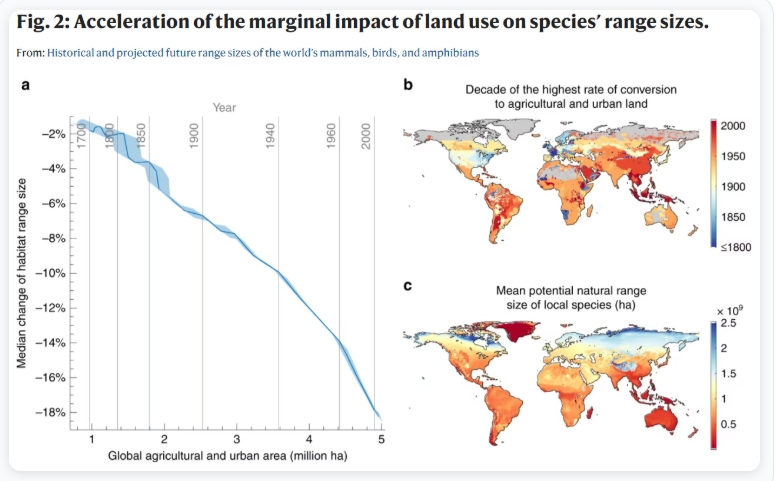
For my own project, I would like to develop a more focused map that examines a specific national park and the surrounding land over time.
References
Zewe, A. (2025, January 17). Explained: Generative AI’s environmental impact. MIT News. https://news.mit.edu/2025/explained-generative-ai-environmental-impact-0117
National Park Service. “Land Use.” Greater Yellowstone Inventory & Monitoring Network. https://home.nps.gov/im/gryn/land-use.htm.
“Habitat Destruction Statistics.” https://ar.inspiredpencil.com/pictures-2023/habitat-destruction-statistics.